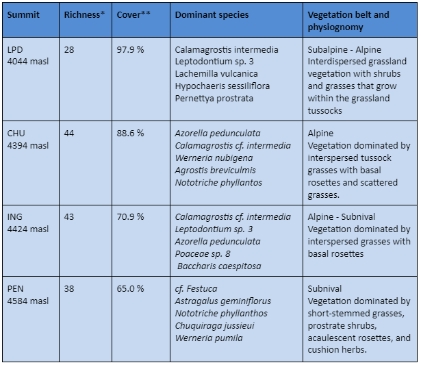
* Total number of vascular plant species (including all summit area sections)
** Mean total cover of vascular plants in the 16 1m2 plots
General characteristics
Species cover and uniqueness
Soil temperature
General characteristics
Description
The paramos of the Pichincha volcanic complex consist of several successive volcanic buildings, built on the Pliocene-age volcanic series of this part of the western Cordillera of Ecuador. Elongated and asymmetrical, this complex measures 20 km from east to west, 13 to 20 km from north to south, and has an altitudinal variation at its base of 2500 to 3000 m from east to west. Along the elevation gradient, a transition from monotypic Polylepis forests, to the shrub páramo, pajonal páramo and the superpáramo is observed.
The four summits that conform this site were selected between November 2010 and June 2011 considering a design of an altitudinal transect from the subalpine belt to the subnival belt (Figure 1). The La Despensa summit (LDP, 4044 m) is close to the upper limit of the Polylepis forests of the Mindo River and is located between the transition of the shrubby páramo and the pajonal or grassland páramo; Cerro Chuquiragua (CHU, 4394 m) is located at the southern limit of the site and demarcates the eastern limit of the glacial valley of the Guagua Pichincha volcano and the origin of the El Cinto river; Cerro Ingapirca (ING, 4424 m) is located to the northwest of the main building of Rucu Pichincha and its vegetation is mainly made up of cushions, basal rosettes and erect grasses; El Padre Encantado (PEN, 4584 m) is one of the main summits of the volcanic complex and limits the site at its eastern end, mainly composed of vegetation of the upper superparamo, typical of the tropical subnival belt.
Prospecting and installation of the site began in November 2011 and ended in February 2012. The first re-measurement took place between December 2017 and January 2018.
Location
Located in the Paramos of Pichincha is in the Western Cordillera of the Ecuadorian Andes (0°.7.4′ LS y -78.3 LO).
Summits
La Despensa (LDP, 4044 masl), Cerro Chuquiragua (CHU, 4394 masl), Cerro Ingapirca (ING, 4424 masl), Padre Encantado (PEN, 4584 masl)
Responsible Institution: Universidad de San Francisco de Quito y Pontificia Universidad Católica del Ecuador (PUCE)
Site coordinators: Francisco Cuesta (fxcuestacamacho@gmail.com) y Priscilla Muriel, (priscilla.muriel@gmail.com)
Database managment:Priscilla Muriel
Botanist/Taxonomist: Sisimac Duchicela y Priscilla Muriel.
 HSP")
Pichincha, Ecuador Cumbre CHU (4394m) HSP
Species cover and uniqueness
SITE RICHNESS: 72 SPECIES, 54 GENERA, 30 FAMILIES

Soil temperature
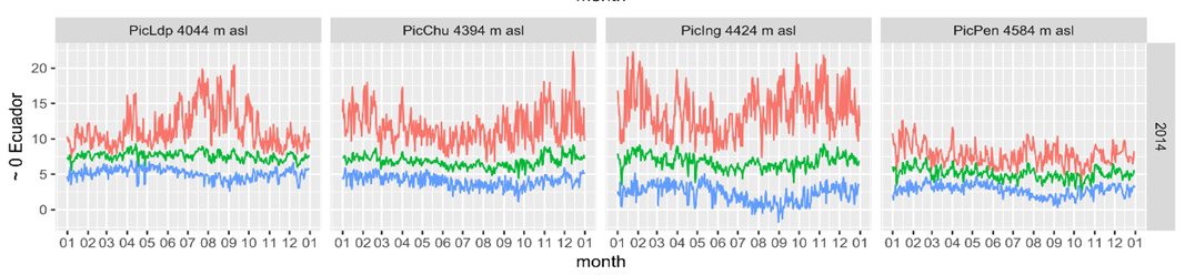
Soil temperature monthly values (-10 cm) mean, maximum and minimum of Complejo Volcánico Pichincha, analyzed from temperature data loggers located in each summit as part of GLORIA methods.