Methods
GLORIA Field Manual
GLORIA uses a multi-summit approach as the basis of its standardized field protocol, emphasizing comparability between study sites.
Each GLORIA target site consists of three or four summits (with at least 2 aspects each one) located at different elevations, ideally above the tree line up to the limit of vascular plant life, in areas with little direct human influence.
In each summit, vegetation composition and cover and the cover of different substrates are measured at the level of summit sections and in sixteen 1m2 quadrants.
Each summit is divided into eight sections, at 5 and 10 m from the highest summit point (HSP) and in the four cardinal orientations (north, east, south and west). In each orientation, at 5 m from the HSP, a 3 x 3m cluster is established, where four quadrants of 1×1 m are installed in each of the vertices and a temperature data logger is located at the center (Figure 1).
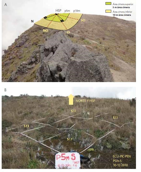
Figure 1. (A) Photo of a summit and monitoring scheme. (B) 3 x 3m cluster. The four vertices or corners constitute the four permanent 1m2 quadrants (where vegetation and substrate cover and species composition are measured); a temperature data logger is placed in the central quadrant of each 3×3 m cluster (photo from Cuesta et al 2012).
Extended Gloria: Other Monitoring Strategies Associated with Gloria Sites
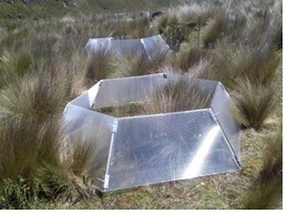
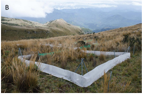
Figure 2. A) Photo of Open Top Chambers from module 2 and B) herbivory exclusion experiment of module 5 (Photos from Báez et al 2014).
Monitoring of biodiversity, productivity and experimentation in Andean herbaceous ecosystems (Báez et al., 2014).
This protocol includes the following modules that are carried out following a standardized methodology: 1) Plant biodiversity monitoring, through permanent plot establishment. 2) Experimental evaluation of the effects of climate change, using Open Top Chambers (OTC). 3) Plant physiology, to evaluate the effects of extreme temperatures on plants. 4) Nutrient manipulation and 5) Experimental exclusion of herbivory (Figure 2).
Monitoring of Stocks and Flows of Carbon in High Andean Altitudinal Gradients (Calderón et al 2013).
This protocol seeks to quantify the carbon content in the most important compartments of mountain ecosystems, and their carbon flows. The protocol is organized in a modular way. The first section focuses on the quantification and monitoring of carbon contents in aerial biomass and necromass, belowground biomass and soil organic carbon. The second section of the protocol describes the quantification and monitoring of carbon flows between the compartments of these ecosystems (Figure 3).
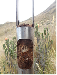
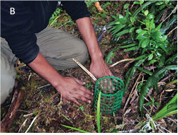
Figure 3. A) Soil samples for belowground biomass estimation, B) Core for root measurement (Photo from Calderón et al. 2013).
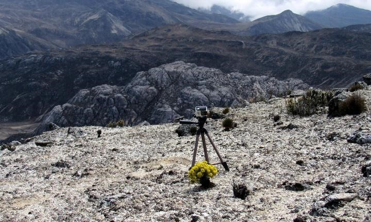
Figure 4. GOPRO cameras used for registration of flower visitors at the summits. In front of the camera Draba chionophilla flowering plant, La Culata Piedras Blancas Site, Venezuela (Photo from Pelayo et al. 2020).
Protocol for Monitoring of Phenology and Pollinization in Summits of the Gloria Andes Network (Pelayo et al 2020).
This protocol is being implemented in La Culata-Piedras Blancas site in Venezuela and seeks to monitor the reproductive ecology of high Andean plants and establish a baseline that will allow the long-term analysis of flowering and fruiting phenology and the plant – pollinators networks in the GLORIA-Andes network and globally. It will also allow the evaluation of changes in the abundance of species, increases or decreases in the flowering and fruiting periods of some species, as well as the increase or loss of pollinators and/or modifications in the structure of the plant-pollination networks (Figure 4).