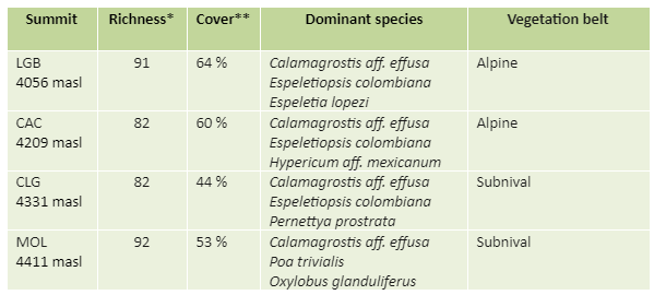
* Total number of vascular plant species (including all summit sections)
** Mean total cover of vascular plants in the 16 1m2 plots
PARQUE NACIONAL NATURAL EL COCUY (CO-CCY)
Description
El Cocuy NNP is a unique protected area in the Eastern Cordillera due to its elevation, which reaches more than 5000 meters above sea level, and includes the presence of ice caps. This last characteristic makes Cocuy an important hydrological zone, since numerous rivers have their origin in this sector, flowing towards the Magdalena and Orinoco river basins. Cocuy includes most thermal belts found within the Colombian territory, from the equatorial rainforest at 700 m asl, through cloud forests between 1500 and 3000 m asl, then through the area of páramo and superpáramo up to 4200 to the perpetual snows from 4800 to 5330 m asl culminating in the Ritacuba Blanco peak.
The installation of the site began in March 2010 and ended in June of the same year.
Location
This site is located on the Eastern Cordillera between the departments of Boyacá, Arauca and Casanare, at approximately 6.361 LN and -72.350 LO.
Summits
Lagunillas Bajo (LGB, 4056 masl), Camino Alto del Conejo (CAC, 4209 masl), Cerro Lagunillas (CLG, 4331 masl), Cerros del Molino (MOL, 4411 masl).
Responsible Institution: Universidad del Rosario y Pontificia Universidad Javeriana
Site coordinator: Adriana Sánchez
Batabase manager: Adriana Sánchez
Botanist/Taxonomist: Jorge Jácome
Research associate: Juan Carlos Benavides
SITE RICHNESS: 118 SPECIES, 66 GENERA, 33 FAMILIES

No data temperature